
Monsoons are expected to hit Thiruvananthapuram on June 1: Monsoon rainfall to be normal this year: IMD

The India Meteorological Department (IMD) has announced that it expects monsoon rainfall to be normal this year. “Southwest monsoon seasonal (June to September) rainfall over the country as a whole is likely to be normal (96-104%),” the IMD said in its first stage Long Range Forecast (LRF) for monsoons. Addressing a press conference through video link, Secretary of Ministry of Earth Sciences Dr. M. Rajeevan released the IMD’s Long Range Forecast for the 2020 Southwest Monsoon Season Rainfall. Director General of IMD, Dr. M. Mohapatra was also present. The IMD also issued the ‘New Normal Dates of Onset/Progress and Withdrawal of Southwest Monsoon Over India’.
Dr. Rajeevan said that quantitatively, the monsoon seasonal (June to September) rainfall is likely to be 100% of the Long Period Average (LPA) with a model error of 5%. The LPA of the season rainfall over the country as a whole for the period 1961-2010 is 88 cm.
“Good news is that it is estimated that the deficient rainfall will be 9 per cent. This forecast is based on the statistical model, it suggests that we will have a normal monsoon”, he said. He said, IMD will issue the updated forecasts in the last week of May/first week of June 2020 as a part of the second stage forecast. Rajeevan pointed out that “ Neutral El Nino Southern Oscillation (ENSO) conditions are prevailing over the Pacific Ocean and Neutral Indian Ocean Dipole (IOD) conditions are prevailing over the Indian Ocean. Some climate model forecasts indicate these conditions are likely to persist during the ensuing monsoon season”. “As sea surface temperature (SST) conditions over the Pacific and Indian Oceans are known to have strong influence on Indian monsoon, IMD is carefully monitoring the evolution of sea surface conditions over the Pacific and the Indian oceans,” he added adding that La Nina, or cooler-than-usual sea surface temperatures in the east-central Pacific Ocean, is typically associated with better monsoon rains and colder winters in India while El Nino is associated with below-normal rainfall in the country.
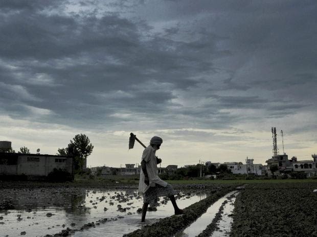
The southwest monsoon season, that replenishes the country’s farm-dependent economy, first hits the southern tip of Kerala usually in the first week of June and retreats from Rajasthan by September.
Monsoons are expected to hit Kerala’s Thiruvananthapuram on June 1. In states like Maharashtra, Gujarat, Madhya Pradesh, Chhattisgarh, Telegana, Andhra Pradesh, Odisha, Jharkhand, Bihar and parts of Uttar Pradesh, monsoon will be delayed by 3-7 days compared to the existing normal dates. However, over extreme northwest India, the monsoon arrives now little earlier, on 8th July compared to the existing date of 15th July.
Monsoons are expected to withdraw in south India on October 15.
Given below are details:Summary of the Forecast for the 2020 Southwest Monsoon Rainfall
- Southwest monsoon seasonal (June to September) rainfall over the country as a whole is likely to be normal (96-104%).
- Quantitatively, the monsoon seasonal (June to September) rainfall is likely to be 100% of the Long Period Average (LPA) with a model error of ± 5%. The LPA of the season rainfall over the country as a whole for the period 1961-2010 is 88 cm.
- Neutral El Nino Southern Oscillation (ENSO) conditions are prevailing over the Pacific Ocean and Neutral Indian Ocean Dipole (IOD) conditions are prevailing over the Indian Ocean. Some climate model forecasts indicate these conditions are likely to persist during the ensuing monsoon season. However, a few other global climate models indicate possibility of development of weak La Nina conditions over the Pacific Ocean during the second half of the season.As sea surface temperature (SST) conditions over the Pacific and Indian Oceans are known to have strong influence on Indian monsoon, IMD is carefully monitoring the evolution of sea surface conditions over the Pacific and the Indian oceans.
over the country as a whole is given below:
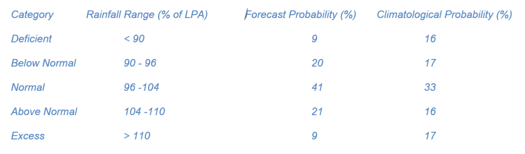
The statistical model suggests high probability (41%) for 2020 monsoon rainfall to be normal (96-104% of LPA).
3. Sea Surface Temperature (SST) Conditions in the equatorial Pacific & Indian Oceans
Currently, El Nino Southern Oscillation (ENSO) neutral conditions are prevailing over the Pacific Ocean. The latest forecasts from some global climate models indicate neutral ENSO conditions are likely to persist during the monsoon season. However, few other global climate models including MMCFS indicate possibility of development of weak LaNina conditions over the Pacific Ocean. It may be mentioned that the global climate model predictions prior to and during the spring season generally have noticeable uncertainty due to spring barrier in the seasonal predictability. At present, neutral Indian Ocean Dipole (IOD) conditions are prevailing over the Indian Ocean. The latest forecast from the MMCFS and global models together indicate neutral IOD conditions are likely to persist during the season.New Normal Dates of Onset/Progress and Withdrawal of Southwest Monsoon over India: The present normal monsoon onset and withdrawal dates are based on records of only a few stations (149 stations) during the period 1901-1940.India Meteorological Department (IMD) has now revised the normal onset and withdrawal dates based on recent data. The normal dates of onset are revised based on data during 1961-2019 and normal dates of withdrawal are revised based on data during 1971-2019. IMD has designed new objective criteria for defining monsoon onset over the entire country based on daily gridded (1ox1o) rainfall data set. The new objective criteria used for deciding monsoon onset/progress dates are designed so as to closely simulate IMD’s operational onset dates. However, the new withdrawal dates are fixed using the IMD’s operational withdrawal dates during 1971-2019. Monsoon onset over Kerala remains the same, i.e., 1 June. However, new monsoon advance dates over the states like Maharashtra, Gujarat, Madhya Pradesh, Chhattisgarh, Telegana, Andhra Pradesh, Odisha, Jharkhand, Bihar and parts of Uttar Pradesh are delayed by 3-7 days compared to existing normal dates. However, over extreme northwest India, the monsoon arrives now little earlier, on 8th July compared to the existing date of 15th July. There are however appreciable changes in the monsoon withdrawal dates, especially over Northwest and Central India. Monsoon withdraws from NW India almost 7-14 days later from the existing dates. There is no change in the final withdrawal date over south India, i.e., 15th October. These new dates are relevant for many applications like agriculture, water and power management etc. The new and older onset and withdrawal dates are shown in Fig 1.{ Image courtesy :The Business Standard}